Boghani Pragnesh

Sunday, 28 February 2016

U.S. Police Forces Ponder Drone Buys Amid Legal Concerns


As public-safety agencies worldwide continue to discover more and better ways to use drones (examples herehere andhere), American police officials wrestle with questions regarding whether or not their departments should take the UAV plunge given so much ambiguity regarding drone regulation at the state and municipal level.
In Rochester, Minn., the local police department thinks drone deployment could help quickly locate a suspect immediately following a crime. Led by Officer Rey Caban, the department isrequesting one drone to be used for “missing or endangered persons cases, hostage situations, dangerous apprehensions or even in natural disasters.”
Although the department has not decided on a specific model yet, officials say they want to spend $15,000 for a drone that can fly for at least 30 minutes to be equipped with thermal and night-vision camera capabilities.
“The main goal of having a UAV for the department is to save lives, it’s not to spy on people,” Caban told the Post-Bulletin. The measure must be approved by the county commission after a public hearing.
Currently, Minnesota has no laws dealing with drone use by police — however, as writer Taylor Nachtigal points out: “Changes will likely come after legislationwas introduced in the Minnesota Legislature last session that would regulate drone use and ban their use for gathering ‘evidence or other information on individuals.’”
Meanwhile in Snohomish County, Wash., the chief pilot of the sheriff’s office is advising public safety agencies in the region to delay making any drone purchases for now as the Evergreen State’s own legislature contemplates new UAV rules. Sheriff’s Officer Bill Quistorf believes there are too many privacy concerns under debate.
“We’re not even close to using it for law enforcement,” Quistorf said in an interview with The Herald of Everett, Wash. “There are larger hurdles to clear if we have any proposed plan to use it for law enforcement.”
Currently, the state legislature is still reviewing drone policy. In 2014, Gov. Jay Inslee vetoed lawmakers’ first effort to regulate UAVs. Quistorf told reporters that he predicted “public agencies eventually will be required to keep archives of drone flight logs, operator information, aerial photos and videos. All of that information could be disclosable under public records laws – that raises concerns because drones are likely to capture images of people’s faces, license plates and other data, he said. Those issues need to be sorted out.”
Of course, any new state laws concerning drones may be rendered moot after the FAA released a Fact Sheet in December warning that the federal agency retained sole “authority to regulate the areas of airspace use, management and efficiency, air traffic control, safety, navigational facilities, and aircraft noise at its source.”

Friday, 26 February 2016

Parrot Invests Another $7 Million in MicaSense


Parrot, the French high tech company best known for its consumer drones,  has invested another $7 million in MicaSensea Seattle based firm that develops remote sensing solutions for the agriculture market. This brings Parrot’s total investment in MicaSense to $9 million. MicaSense received $2 million in funding from Parrot in 2014.
Yesterday Parrot announced Sequoia, a multispectral sensor for the agriculture market. MicaSense is adding the Sequoia to its existing line of sensors for drones and will use its ATLAS cloud data solution to enhance the use of this new sensor.
ATLAS enables growers and agricultural professionals to easily view and extract information from multispectral data. ATLAS processes Sequoia data through a seamless cloud interface, automatically organizing processed outputs with no manual filtering or sorting. Creating farms and defining field boundaries is easy with an intuitive user interface. Crop health maps can be viewed in the field from any connected device for advanced scouting. Uploading to ATLAS is the easiest and most efficient way to achieve consistent results.
The investment in Parrot by MicaSense reflects Parrot’s commitment to expand into the commercial drone market.

Powervision Robot Announces the PowerEgg Drone


Powervision Robot Inc., has announced their first consumer drone, the “PowerEgg,”. The drone sports an innovative egg shape which, according to Powervision, is aesthetically different and especially easy to to fold and transport. The drone, which is expected to be available in early Q2 of 2016, can be easily carried in a backpack.

Wally Zheng, CEO of Powervision, said, “Powervision wanted to create a beautiful yet functional design for the PowerEgg. We think the oval shape is not only clean and pure but also has the structural and functional benefits. This simple yet vital design means that this is more than a flying robot but a work of art.”

Although developed for the mainstream consumer market, the PowerEgg includes advanced technologies that rival industrial drones. These include:
  • a 360-degree panoramic 4K HD camera on a 3-axis gimbal
  • real-time long range video transmission
  • advanced “optical flow” sensors for indoor navigation
  • an intuitive and easy-to use-remote control,.
  • a unique design includes larger propellers
Another goal of the drone is ease of use. Zheng explained, “We want flying a drone to be child’s play, something even a five-year-old can do.”
Zheng believes  “With this next generation of drones, much like the Internet expanded access to information in the virtual world, drones 2.0 led by innovations like the PowerEgg can expand access to the physical world and bring together humans and machines in this journey.”
Here is a promotional video for the PowerEgg.

This Week in Public Safety Drones


The Drone Revolution is taking the public-safety world by storm. From police surveillance quadcopters to fixed-wing firefighter craft, UAVs are attracting the attention of public-safety agencies across the globe.

Canadian paramedics are hoping a new drone solution could spell the difference between life and death in first-responder crises. The Renfrew Paramedic Service outside of Ottawa recently launched a drone patrol as a primary response plan across a variety of scenarios: finding lost hikers, life-vest delivery to capsized boaters or hazardous material verification following highway crashes. Renfrew contracted with Indro Robotic and Remote Sensing to provide larger drones to carry life-saving medical equipment to a scene such as a defibrillator or epi-pens.
While it may be an exaggeration to say drones protect democracy, police in India are hoping that a new fleet of UAVs may at least help maintain order during upcoming elections. In the Karnataka region, tempers can easily flare in local elections that largely take place among candidates from a single, well-known family. Police say they will use drones to watch polling stations on Feb. 13 after successfully using them to keep an eye on events leading up candidate filings recently. “It made a lot of difference as it added to the overall ability of police performance,” regional police chief Chetan Singh Rathore said.

The national police force of Fiji is getting drones high in the sky to ensure fewer of their population get high from marijuana. According to the Fiji Times, defense and national security minister Timoci Natuva recently told Parliament that drones can help police sniff out weed cultivation in both urban and rural areas. Apparently, growers tend to move their operations frequently once they get wind of police snooping. By using drones, police can increase their surveillance capability ten-fold, Natuva said.

And if drug lords in Fiji are successful in spiriting their wares outside the island nations, any efforts to import their products into New Zealand may face a new challenge. This week, the military police announced they would eventually replace aging aircraft with drones to support police border patrols. The New Zealand Defence Force’s police arm currently has six P-3K2 Orion aircraft scheduled to be retired over the next decade. Officials say they hope advances in drone technology will allow them to instead deploy drones with longer flight times and range to deter or capture illegal fishing operations as well as drug smugglers. “It is still in the early capability definition phase. Remotely piloted vehicles will be considered as part of the project, along with piloted and space-based systems,” a ministry spokesperson said.

Thursday, 25 February 2016

Registration Deadline Approaches: FAA Reminds Operators


The deadline for drone registration is Friday, February 19, and theFAA is reminding drone owners to comply or face still penalties.

The registration program applies to any drone weighing more than .55 lbs. and less than 55 lbs. that will be flown outdoors for recreational purposes.  The registration process is simple and can be completed at FAA.gov.  The $5 fee will give the operator a certificate and registration number: all drones must be marked with a registration number and the operator must have the certificate while flying.

The registration program has been debated by all how to find cialis sides.  The AMA asked their members to hold off on registration until the last possible moment while they try to negotiate a different program.  A lawsuit has been filed against the FAA in protest, questioning the FAA’s right to impose the registration program.  Studies have questioned the utility of a program which only provides a means of retaliation after a mishap, but does nothing to prevent one in the first place.

Regardless of canadian pharmacy viagra generic the criticism, the FAA claims that the program provides valuable educational opportunities. “Besides being required by law, registration provides an excellent opportunity to educate yourself if you are new to aviation, and it will help you become part of the safety culture that has been the hallmark of traditional aviation for more than a century,” said FAA Administrator Michael Huerta.  Basic regulations, such as staying more than 5 miles away from airports and under the 400 ft altitude limit are delivered with the certificate.

The FAA reports that over 342,000 people have registered to date.  With the agency’s own estimates that over 1,000,000 drones were sold during the holiday season alone, it seems that most operators remain unregistered.   Failure to register could be a risky strategy; the consequences include a civil penalty of up to $27,500, criminal fines of up to $250,000, and imprisonment for up to 3 years.

Small Drones Worth $10 Billion by 2020


A new report by Markets and Marketspredicts that the the global market in small drones will grow from 5.80 Billion in 2015 to 10.04 Billion by 2020, at a compound annual growth rate (CAGR) of 11.6%.  The report says that commercial applications will be responsible for most generic trazodone of the growth.

Factors such as rising demand for operational efficiency for surveillance and reconnaissance, and zithromax for dogs minimized human intervention in combat and other risky military operations and in commercial avenues, such as agriculture and transportation for crop monitoring and packet delivery respectively, are the major factors that will drive the global small drones market.

Segmenting the market into mini, micro and nano drones, the report predicts that nano drones will be the fastest growing segment, as nano drone technology improves.  While as demonstrated in the figure above, the current market is heaviest in the US, the Markets and Markets report sees demand shifting to the other side of the world:


The Asia-Pacific region is expected to exhibit the highest growth rate in the small drones market, and is projected to grow at a highest CAGR during the forecast period from 2015 to 2020. The Asia-Pacific market is expected to grow at the highest CAGR, because several Asia-Pacific countries such as India, China, Australia, South Korea, and others have focused production of small drones for commercial and defense purposes, such as crop monitoring, logistics, reconnaissance and surveillance, among others.
While the development of the small drone market may appear to be shifting overseas, the US small drone market- particularly nano drones – may be assisted in the US by the proposed development of a micro-drone classification as part of new FAA regulations.  A micro drone – a drone weighing under 4.4 pounds including payload – does not require a licensed pilot to operate it, and is exempt from other commercial regulations.
In addition, some nano drones may fall under the 9 ounce limit for drone registration in the US, and enjoy a much looser regulation environment.  As nano technology develops, their increased use for commercial purposes may allow the US drone industry to make an effective end-run around the FAA’s current onerous commercial regulation framework.

Wednesday, 24 February 2016

3DR Update


3DR is continuing its effort to establish itself as a leader in drone technology for the photo enthusiast. A pioneer in drone ‘follow me’ functionality (Iris+ is the first consumer drone to be able to follow its user), 3DR has announced Free Look. Free Look allows the drone operator complete freedom to compose and shoot pictures and videos of moving objects without worrying about manually flying the drone.

This capability is a logical outgrowth of standard follow me functionality. That functionality, which is available with a variety of drones, allows you as an individual operator to have a drone follow (and film) you while you are moving. It is popular with outdoor recreational users (skiing, mountain biking, etc). It tethers the drone to the user and keeps the camera focused on that user without the need to control it.

First Look is special, because it enables the drone to follow someone else while you focus on the filming. It shares the hands free notion of ‘follow me’ but in this case it is not so much follow me as follow them. Here is how 3DR explained it via a use case scenario on in a recent blog entry

"Use case: Let’s say you want to follow a subject driving an ATV. Have Solo follow your vehicle while your vehicle follows (or is near) the subject on the ATV. Control Solo from inside your vehicle, using the FPV video as guide. Go into Follow, toggle Free Look, and Solo is leashed to the vehicle you’re in. You now have complete control over the composition of your shot as you tail the ATV, putting the camera exactly where you want to put it while Solo flies along. This lets you do what no other Follow can: Actually compose your shots. You don’t always want a centered subject — this makes Follow much more visually interesting, and it turns it from a flat, automatically centered shot into a real filming tool."

First Look allows the camera-equipped drone operator control over the composition of the shot. “You can also now design camera moves that start with one subject in the frame, then pan or travel to another subject or area,” according to 3DR. It has an orbit capability that can circle around a person while that person is in motion.

Chinese Camera


New research published by International Data Corp (IDC)  shows the Chinese camera drone market is exploding.

IDC recently introduced the “China Quarterly Camera Drone Tracker Q3 2015”. The report says that while China’s camera drone industry is new, it may see a huge increase over the next five years, potentially  reaching 3 million units by 2019.

The IDC research indicates several new market trends, including 4k recording, so far provided only by Chinese manufacturers DJI and Yuneec.  Researchers predict that there will be increasing downward price pressure for camera drones, which may favor China; and that distribution channels will become more and more generalized, with drones more widely available online and at retail stores.

IDC also predicts that commercial applications will become a greater demand driver for camera drones, as innovators find increased uses in a variety of verticals.  The report estimates that 30% of the entire camera drone market may be commercial by 2019.


While the IDC researchers find that DJI held on to almost 70% of the market in late 2015, a shakeup could be in the works as new providers gain investors, and existing players such as Sony enhance their offerings.

Drone Help


DroneDeploy Releases Elevation Toolbox and Volume Measurement Tool


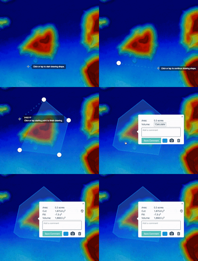
DroneDeploy is excited to announce the release of their Elevation Toolbox and new Volume Measurement tool. This tool enables DroneDeploy users to calculate the volume of stockpiles, measure the extraction volume of a quarry or estimate the volume of a building,  instantly from any device. It delivers accurate and timely volume calculations are critical across a wide range of industries including mining, construction, processing and manufacturing.

"Any Map processed after 7am PT Feb 3, for users on 30 day trial, Pro or Precision will have volumetric capability"

Monitoring stockpiles for one of the largest wheat processors in the Southern Hemisphere is serious business, particularly when those stockpiles are fuel sources. Not only does information about fuel usage help them make better purchasing decisions, it also helps them know when boilers are consuming fuel inefficiently and need maintenance. Since substituting drones for professional ground-based surveys they have seen their cost for volume measurements drop by half and time savings increase significantly.

Volume measurement is yet another example of the many ways that drones are helping businesses innovate. Rather than spending thousands of dollars per survey for ground-based laser measurement, you can now fly your drone over your stockyard, mine or construction site and use DroneDeploy to quickly and easily make a volume calculation. You don’t have to sacrifice accuracy either. In early tests, users reported volume measurements within 1–2% of professional survey readings.

How to Measure Volume

It’s insanely fast and easy to use our volume tool from any device. Simply go to your map on DroneDeploy and select the perimeter of the feature (e.g., stockpile) you want to measure. Then click the “Calculate” button to instantly compute the volume.


Behind the scenes, we create a base from the perimeter you identify. This base is intelligently created to match the surface contour of the surrounding land, meaning we’re able to compute accurate volumes even if your stockpile resides on a hill with some curvature.

We then calculate the volume between this base (representing the bottom of the stockpile or the top of a pit) and the surface of the stockpile or pit as represented by the elevation data from your map.


Sunday, 21 February 2016

Drones

New Drones


The good The DJI Phantom Vision 2+ is an easy-to-set-up and ultimately simple-to-pilot quadcopter drone for aerial photos and video. It's fun to fly, well-constructed, has very good battery life for its class and can painlessly be set to navigate a flight path autonomously.

The bad Video quality is on par with a lower midrange POV camera. Though flight times are longer than those of most RTF copters, you'll want to factor in an extra battery or two and spare propellers into the cost. Ground Control features might be too limited for more experienced users.

The bottom line An excellent entry point into the world of aerial photos and video, DJI's Phantom 2 Vision+ is worth the cost for its simple setup and use.